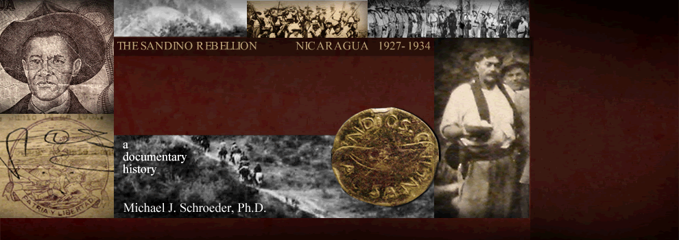
|
 This page houses sketches of maps
produced by the commanders of combat patrols,
most dating from the period 1928-1930,
when the geographic knowledge of the Marines &
Guardia was sparse and the Second Brigade's
Mapping Section hungry for more detailed
information about the spatial characteristics of
the country the Marines had invaded & occupied. This page houses sketches of maps
produced by the commanders of combat patrols,
most dating from the period 1928-1930,
when the geographic knowledge of the Marines &
Guardia was sparse and the Second Brigade's
Mapping Section hungry for more detailed
information about the spatial characteristics of
the country the Marines had invaded & occupied.
Generally these
sketch maps also appear in PC-Docs,
along with the patrol & combat reports with
which they were submitted & archived.
|

|
"Sketch Map, Vicinity of
Sapotillal Ridge, Nueva Segovia, 9
October 1927." See
PC-DOC 27.10.12 O'SHEA.
|
|

|
"Sketch of Scene of Action,
Capt. Livingston's Column, 30 December
1927." See
PC-DOC 27.12.31 GOULD.
|
|

|
"Sketch showing the disposition
of Marine and Bandit troops at the
Battle of Las Cruzas, January 1st,
1928." See
PC-DOC 28.01.04 BROWN.
|
|

|
Sketch of zone from San Juan de
Telpaneca to San Rafael del Norte, P.
Reyes & P. Geyer, 5 February 1928.
See
PC-DOCS 28.03.05 Rockey.
|
|

|
"Rough sketch of Remangon Area
and Area east of Quilali and Chipote, by
R. H. Patterson, 4/1/28"
(1 April 1928).
|
|

|
"Contour Sketch, Trinidad-San
Isidro and Ollanco Mountain, Sketched by
Cpl. H. T. Provost, by order of 1st Lt.
B. W. Atkinson, 5th April, 1928."
See
PC-DOC 28.04.05 ATKINSON.
|
|

|
"Trinidad, Sketch of Center of
Town, Sketched by Cpl. H. T. Provost, By
Order of 1st Lt. B. W. Atkinson, 5th
April 1928." See
PC-DOC 28.04.05 ATKINSON.
(Also housed under Photo Pages > Maps >
Cities
& Towns.)
|
|

|
"Trails to La Oriental, Sr.
Rafael Kuan."
Accompanying
PC-DOC 28.04.05 HART.
|
|

|
"Rough Sketch [of Rio Tuma-La
Trampa area east of Jinotega] — Patrol
May 7, 1928." See
PC-DOC 28.05.09 KILCOURSE.
|
|

|
"Map of trail San Albino -
Congohoes [Congojas], Route taken by Lt.
Ridderhof's patrol." See
PC-DOC 28.05.17 RIDDERHOF.
|
|

|
Sketch Map of Guapinol—Peña
Blanca area. See
PC-DOC 28.05.24 CLAUDE.
|
|
|
More forthcoming . . .
|
|
|
|
|